CHESTERVILLE SEWAGE LAGOONS
Spring: ** Summer: *** Fall: *** Winter: *
Warning: Sewage lagoons generally do not welcome visitors. Liability insurance is behind much of their reluctance. In the past, they have often made an exception for birders. For some lagoons, the OFNC and/or independent birdwatchers have arranged special access with the operators or wardens. Contact the OFNC to find the current arrangements, if any. Some lagoons are partly visible without crossing the fences, though because of the brem construction, many are not visible from the road. Lagoons are generally not heavily patrolled or impassibly fenced, and when trespassers are unwelcome they are usually just asked to leave; so many birders assume the "No Tresspassing" signs are for someone else (especially given past tolerance). Once in a while, especially in hunting season, hunters make the same assumption. They are less welcome than birders though and are often reported by the locals. After one of these incidents, patrols may be more frequent. The rules seem to change as often as the folks assigned to enforce them; some are more tolerant than others (some are downright helpful). Use courtesy and common sense. And when you park near a sewage lagoon, please don't block the access roads. Even without crossing the fences, a patient and competent birder can see many species as they fly into and out of the lagoons.
Independent Directions to this Site: From Highway 417 (The Queensway) take exit 96 (Boundary Road). Proceed 20.0 km SSE on Boundary Road (Regional 41) to Marionville Road at Marionville. Turn left or ENE onto Marionville Road (County Road 7) and drive 4.0 km to where County Road 7 makes a righthand turn and heads SE. Continue a further 12.2 km southeast on County Road 7 to Water Street in Chesterville, where County Road 7 is also known as Main Street North. Turn left onto Water just before reaching the bridge and go 0.4 km east on it to an unnamed street (to Cross Road) on the right just before Water Street ends up in a parking lot. Follow this road, which turns left or east after 0.1 km to follow the riverbank. After about a kilometre you will see the Chesterville Sewage Lagoon on the left or north side.
Eastern Sewage Lagoons Route Route Directions: From the Winchester Sewage Lagoons entrance on Liscumb(e) Road (County Road 3), return WSW 0.9 km to the 90 degree lefthand turn, then continue SSE on Ottawa Street (still CR 3) for 1.3 km to Main Street in Winchester. Turn left or ENE onto Main (later Boyne Road) and proceed 1.6 km to Belanger Road. Turn right or SSE onto Belanger and go 2.6 km to Regional 43. Turn left or ENE onto 43 and proceed 6.8 km to Queen Street West. Turn left or ENE onto Queen and go 1.0 km to Main Street North or County Road 7. Turn right or SSE onto it and follow it 0.4 km to Water Street. Turn left onto Water just before reaching the bridge and go 0.4 km east on it to an unnamed street to Cross Road) on the right just before Water Street ends up in a parking lot. Follow this road, which turns left or east after 0.1 km to follow the riverbank. After about a kilometre you will see the Chesterville Sewage Lagoon on the left or north side.
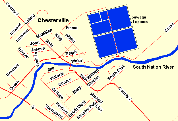 Map of Chesterville Lagoons area
Site Description and Birding Information: These lagoons are just outside the Ottawa Checklist Circle, but seemed to clearly fall into this route. The road into the lagoons runs along the South Nation River. It passes the lagoon on the low or river side and does not allow for any view over the brem even where the road rises slightly just beyond the lagoon. The fence seems to have holes used which may have been used by trespassers (an observation only, not an encouragement). There is a gate at the midpoint between the two southern cells adjacent the river road. Beyond those there is a gully with a fence, separating them from four other cells. The northeastern cell is similar in size to the southern cells, but in the northwestern quadrant there are three cells. The more southerly is half the quad, while the northerly half is divided again, the smaller cell being more central. These lagoons have not been quite as productive as Winchester, but can turn up some interesting migrants, especially shorebirds.
An alternate approach, especially for the northerly cells, is the main entry road into the Nestle owned portion of the sewage facillities, near the railroad tracks. This can be reached from Main Street North, 0.8 km north of its junction with Water Street, by going ENE on Emma Street for 0.8 km. Permission to enter this section may be granted at the gate house. But after-hours entry is frowned upon; considered a security risk. The plant section is monitored by a security camera.
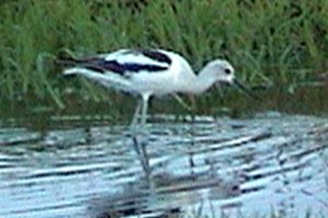
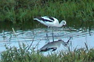 American Avocet - Chesterville Lagoons - Sep. 14, 2003
All the regular species of shorebirds which pass through the Ottawa area have been seen here. Uncommon species are sometimes seen, including Stilt Sandpiper, and Red-necked and Wilson's Phalarope. Keep a eye out for flight activity by the shorebird flocks, indicating that they may have spotted a threat. Such threats may be an avian predator. Watch also for migrating swallows, waterfowl and gulls. Rarities seen here include: American Avocet (Sep. 14 - 20, 2003 - in the smallest of the three northwestern cells).
 Some Birds are Easier to ID in Flight
White-rumped Sandpiper and Lesser Golden Plover
Some Birds are Easier to ID in Flight
White-rumped Sandpiper and Lesser Golden Plover
Eastern Sewage Lagoons Route Route Directions: From the Chesterville Sewage Lagoons return about a kilometre west to River Street. Turn left or west on it and go 0.4 km to Main Street North or County Road 7. Turn left or northwest and follow County Road 7 for 12.2 km to where it makes a 90 degree left turn at the Marionville Road. Follow CR 7 to the left or southwest for 1.4 km to County Road 6 or South Russell Road. Turn right or NNW onto it and drive 4.1 km to Route 400. Turn right or northeast onto Route 400 and go 1.4 km to Wade Road. Turn left or NNW on Wade and proceed 2.5 km to the road on the right to the next site on this loop, the Russell Sewage Lagoons.
Return to Eastern Sewage Lagoons Route.
Return to Birding Ottawa Table of Contents.
|