BATE ISLAND
Spring: ** Summer: ** Fall: ** Winter:**
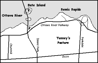
Independent Directions to this Site: From Highway 417 (The Queensway) take exit 123 (Island Park Drive) if travelling west or exit 124 (Carling Avenue) if driving east. Using the Carling exit requires a bit of manouvring. Immediately upon exiting, in 250 metres, you will merge with Carling Avenue. As left turns are prohibited onto Merivale Road, which joins Island Park Drive, you will want to cross the traffic lanes and turn left onto Kirkwood Avenue and have only another scant 250 metres in which to do it. Be careful! Avoid rush hours, traffic can slow to a crawl, especially crossing the bridge to Quebec. Go NNW on Kirkwood for 1.2 km and turn right on Byron Avenue. Proceed 0.4 km ENE on Byron to the traffic light at Island Park Drive. Here you will join the route of those travelling west on the 417, who had only to exit onto Island Park Drive and go 0.9 km NNW along it to reach Byron. From Byron and Island Park continue NW along Island Park to the Champlain Bridge and part way across it, making a righthand turn onto Bate Island, 2.0 km from Byron Avenue. Sometimes, the road on the island is closed. But you can usually park in the parking lot at the base of the bridge on the Ottawa side. To do this turn right onto the Ottawa River Parkway before crossing the bridge, then left into the parking lot about 150 metres from the corner.
Ottawa River West: Ontario Route Directions: From Remic Rapids turn right or southwest and proceed 1.1 km to another pulloff on the right. Turn right or west into the parking lot for another view of the Remic Rapids at the base of the Champlain Bridge. This view is normally not as productive, but when searching for a species known to be hanging around the rapids, it provides another opportunity to find it. It is also a handy parking spot from which to check Bate Island when the access roads from the bridge are closed. Sometimes the road is cordoned off to Bate Island, so it is necessary to park here or near the far side of the bridge (where traffic is a major problem). Proceeding on foot from the parking lot, the birder can go directly to the nearest access to the south end of the bridge and follow the sidewalk northwest 0.5 km to the Bate Island turnoff. If the roads are open, the instructions that follow will work. Leave the parking area and turn right again on the Ottawa River Parkway and proceed 0.2 km (or 1.3 km from Remic Rapids) southwest to the junction with Island Park Drive and the Champlain Bridge. Turn right or north onto the Champlain Bridge and go 0.7 km (part way) across it, making a right-hand turn onto Bate Island.
Site Description and Birding Information: In the middle of the Ottawa River, Bate Island provides an excellent view of avian traffic going up or down the river. The Ottawa is fairly narrow here, the main channel, between Bate Island and the Quebec shore, being only about 550 metres. The Remic Rapids are in this section of river. This is possibly the best spot for jaeger watching along the Ottawa. Rafts of Common Goldeneye gather in spring and fall, and as long as the water is open in winter. One or more Barrow's Goleneye are usually among them. The island is well groomed, and consequently not so inviting for birds, but if you are there in season, check the trees and the few scrubby bits for migrant land birds. The one-way road makes a counter-clockwise loop around the island and returns to the bridge from the southwest side. There are lots of parking areas on the loop, including spots where portions of the river can be viewed from a vehicle, handy when it's 20 below.
Late fall, early spring and in all but the coldest winters (when this part of the river freezes); flocks of goldeneye feed above the rapids (both Remic and Little Chaudière to the east) and rest in the conveniently placed bays off Parc Brébeuf and Remic Rapids. The bays can be scanned from the eastern end of Bate Island with a spotting scope; but viewing is often better from the two sites cited above. See also the Champlain Bridge site located at the Quebec end of the bridge.
During the peak of gull and tern activity at Deschênes Rapids - Ontario or Quebec, it is a good idea to watch for patrolling birds working along the river. Less common birds, such as Bonaparte's Gulls and Common and Black Terns can be present, and rarities like Caspian Tern can show up along with the more common birds. If the river is low, exposed rocks provide roosting areas for gull flocks and sometimes sandpipers, including Purple Sandpiper in early November.
Jaegers, though rare in this neck of the woods, have been seen from Bate Island more often than anywhere else in our area. Parasitic are the most likely, though Pomarine and Long-tailed have both occurred. Based on all reports in the Ottawa checklist area, September is the best month to watch for Parasitic's, though a few have been seen in June. Pomarine's have occurred from mid-September to mid-November. What Long-tailed's that have been spotted near Ottawa, have been in June. Since these birds are either on their way to the arctic or coming back from it, they rarely linger here and are typically flying purposefully along the river, occasionally harrassing some unlucky tern or gull to make it cough up a meal.
A colony of Cliff Swallows nests under the Champlain Bridge.
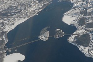
If you walked from the Ottawa River Parkway parking area, be sure to take advantage of the opportunity to do some canopy birding when passing over Riopelle Island, between Bate Island and the Ontario side of the river. Also take advantage of the bikepath underpass to the west to visit a woodlot that in the past has been good for late fall and winter specialties like Bohemian Waxwing and Pine Grosbeak. Owls and winter finches have been seen here as well.
For those keeping provincial lists, the Ontario/Quebec boundary is about 200 metres from Bate Island and 350 metres from the Quebec shoreline to the NW. To the NE it follows the bend in the river around to the east and sticks closely to the middle of the river.
Rare bird seen here include: Caspian Tern (nearly yearly), Black-legged Kittiwake (Nov. 24, 2002), an immature Franklin's Gull (Sept. 10 to 13, 2005), Harlequin Duck (Nov. 21, 2005; Dec. 14, 2007 to at least Feb. 27, 2008 north of the island to the Quebec shore), Parasitic Jaeger (Oct. 27, 2011).
Ottawa River West: Ontario Route Directions: When leaving Bate Island, turn right or south onto the Champlain Bridge and go 0.7 km to the Ottawa River Parkway. Turn right or west on the Parkway and follow it 0.9 km southwest to the Kitchissippi Lookout turnoff. If you parked at the base of the bridge on the Ontario side, turn right or west on leaving the parking lot onto the Ottawa River Parkway, then proceed 1.0 km southwest to the Kitchissippi Lookout turnoff. Make a right-hand turn to the west into the next site, Kitchissippi Lookout.
Return to Ottawa River West: Ontario.
Return to Birding Ottawa Table of Contents.
|
 Map of Bate Island
 Aerial View of Bate Island (centre)
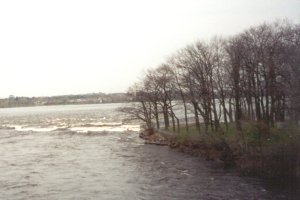
 Rapids on North Side of Bate Island
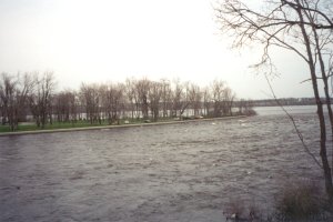
 East End of Bate Island from Riopelle Island
|


