CONSTANCE BAY
Spring: *** Summer: ** Fall: ** Winter: **
Independent Directions to this Site: From Highway 417 (The Queensway) take exit 138 (Eagleson/March Roads). If travelling west, the 0.6 km offramp sends you right or north onto March Road. If driving east, a 0.4 km offramp brings you to Eagleson Road, where you will turn left or north onto it and in 0.5 km join the westbound offramp traffic on March Road (it changed names as you went under the overpass). Both groups will now follow March Road northwest 8.0 km to Dunrobin Road. Turn right or north onto Dunrobin and go northwest 15.5 km to Constance Bay Road. Turn right or northeast on it to begin the Constance Bay segment of our route.
Ottawa River West: Ontario Route Directions: From Constance Creek at Vance's Side Road proceed southeast 1.9 km to Dunrobin Road. Turn right or northwest onto Dunrobin and go 5.0 km to the Constance Bay Road. Turn right or northeast onto it to begin the Constance Bay segment of our route.
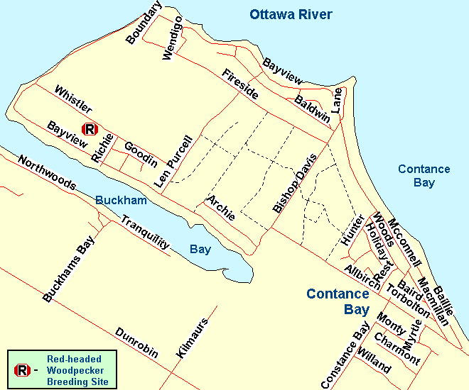 Map of Constance Bay area
Site Description and Birding Information: Constance Bay is notable for its sandhills and attendant pine forest. It is a 3.5 by 1.5 km peninsula in the Ottawa River, with Constance Bay to the southeast and Buckham's Bay to the southwest and a 2.5 km wide bend in the river to the north. This provides ample water to check. There are many trails through the forest.
A pair of Red-headed Woodpeckers has been breeding at a former burn site since 2002. They usually arrive in mid-May and leave by late August. Two or three birds overwintered in 2004-05 and 2005-06, frequenting the burn site and the feeders in the neighbourhood. None wintered in 2006-07, leaving in September. They continued to breed sucessfully at least into 2010. Watch too for other cavity nesters, such as Northern Flicker, Hairy and Downy Woodpeckers, Black-capped Chickadee and even Eastern Bluebird. To reach this spot, turn left off Constance Bay Road 1.5 km northeast of Dunrobin Road onto Allbirch Road and drive 1.3 km northwest to the "T" junction at Bishop Davis Drive. Turn left or southwest onto Bishop Davis and in 0.3 km turn right or northwest onto Bayview Drive. Follow Bayview Drive 1.5 km to Ritchie Street and turn right or northeast onto it. Go 0.2 km to Whistler Road and turn left or northwest on it. Drive 0.3 km and watch for a gate on the right or northeast side. The trail through the burn area is on the left or southwest side, opposite the gate. Parking is limited. Beware the abundance of poison ivy in this area.
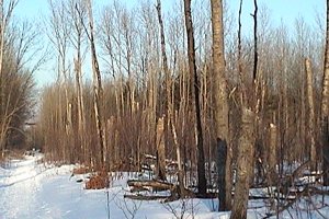 Old Burn Area at Constance Bay
|
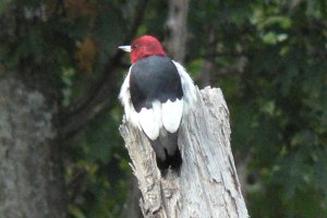 Red-headed Woodpecker at Old Burn Area - Sept. 10, 2006
|
Views of the Ottawa River and Buckham's Bay provide opportunity to check for diving ducks and other waterfowl, gulls and even Arctic Terns in season. These terns pass through the area in late May and early June each year. The best access point for viewing (narrowest point) is behind The Point restaurant, along Bayview Drive, on the Ottawa River side of the peninsula. Here a boat launch access provide extensive views of the river and shoreline. Another good viewpoint is off the Ottawa River end of Constance Bay Road, where a short access road provides good views of the river.
The trails through the forest, some of which are drivable at times, are best birded on foot. They criss-cross the entire woodland and go through both deciuous and conifer areas. Large areas of pine grow on this prodominently sandy soil.
On Oct. 8, 2011 9 Nelson's Sparrows were discovered at the mouth of Constance Creek in Constance Bay, ON (on Oct. 9th 11 were found and at least one lingered until Oct. 17). You will need boots for this. Normally you would need waders but the water was very low in 2011. To get to these birds, it is suggested that you park at the fire access road at the corner of Sand Bay Street and Baillie. Do not block the fire road. Then walk east down the beach along the Ottawa River for about 400 m until you get to the grassy area just past the last house. This is where you should look for the Nelson's Sparrows. The birds are all through this area and were easy to see using quiet pishing. Morning is better for these birds since they react more to pishing then but you may be able to see them anytime. The coordinates of the site are: 45.477453 N, 76.066583 W (using Google Earth). Note that the fire access roads are public access but landowners do not always see it that way. To get there, follow Constance Bay Drive in from Dunrobin Road. Turn right on Baillie just past the liquor store. Sand Bay is about 400 m east.
In the winter of 2004 - 05, a large number of Great Gray Owls stayed around the Dunrobin Road and Kilmaurs Sideroad area, just 1.3 km northwest of the turnoff from Dunrobin Road into Constance Bay. This was one of the best spots to find these impressive birds. This junction alone had 14 owls around it on Jan. 8, 2005. The sideroads within a few kilometres of here had Great Grays present from Dec. 12, 2004 to at least Mar. 21, 2005.
A few hundred metres south of the junction of Constance Bay and Dunrobin Roads watch for Upland Sandpipers. They were seen here in the summer of 2007.
Recent rare birds seen here include: Red-headed Woodpecker (breeding from 2002 to at least 2010 with a high total in 2004 when there were 3 adults and 4 immatures; wintering 2004-05 and 2005-06), Red Phalarope (Nov. 7, 2002), Greater White-fronted Goose (Oct. 16, 2004 & Nov. 8 - 12, 2004), Carolina Wren (Oct. 16 or 17, 2004 - Allbirch Road and Shady Lane), Black-legged Kittiwake (Oct. 19, 2004 - off NW end of Bayview Drive; Oct. 29, 2005 - 1st winter - found dead on beach), Boreal Owl (Dec. 12, 2004 - Monty Drive), Cattle Egret (Nov. 6, 2005).
Ottawa River West: Ontario Route Directions: Exit the Constance Bay area via the southwestern end of Constance Bay Road at Dunrobin Road. Turn right or northwest onto Dunrobin and go 4.7 km to the Galetta Side Road. Turn left or southwest onto it and drive 1.5 km to Woodkilton Road. Turn right or northwest onto it and proceed 2.6 km to the next site, MacLaren's Landing.
Return to Ottawa River West: Ontario.
Return to Birding Ottawa Table of Contents.
|