DUNROBIN SHORE - BASKIN'S BEACH
Spring: ** Summer: * Fall: * Winter: ***
Independent Directions to this Site: From Highway 417 (The Queensway) take exit 138 (Eagleson/March Roads). If travelling west, the 0.6 km offramp sends you right or north onto March Road. If driving east, a 0.4 km offramp brings you to Eagleson Road, where you will turn left or north onto it and in 0.5 km join the westbound offramp traffic on March Road (it changed names as you went under the overpass). Both groups will now follow March Road northwest 8.0 km to Dunrobin Road. Turn right or north onto Dunrobin and go northwest 7.1 km to Dunrobin and the Thomas Dolan Parkway. Turn right or northeast onto it and go 6.0 km to Barlow Road to begin the Dunrobin Shore - Baskin's Beach segment of this route.
Ottawa River West: Ontario Route Directions: From the river end of Pinhey Point Road, return the one kilometer southwest to Sixth Line Road. Turn right or northwest onto Sixth Line Road and proceed 2.0 km to the Torbolton Townline, a.k.a. Thomas Dolan Parkway. Turn right or northeast onto the Thomas Dolan Parkway and go 1.8 km to Barlow Road and the Dunrobin Shore - Baskin's Beach segment of this route.
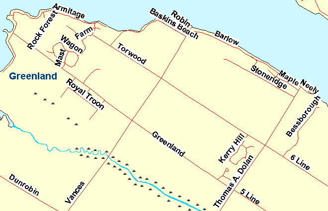 Map of Dunrobin Shore - Baskin's Beach
Site Description and Birding Information: Barlow Road which runs between the Thomas Dolan Parkway and Vance's Side Road 3.5 km to the northwest, and its extentions to the southeast (Neely Street) and to the northwest (Baskin's Beach Road), constitute a year round cottage home area along the Ottawa River. The site is forested, with a good percentage being conifer. A number of feeding stations make this an interesting stretch to visit in winter, especially for finches. Boreal Chickadee and Carolina Wren have also been seen here.
At the end of Thomas Dolan one can view the Ottawa River. It sometimes brings surprises, like the Black-legged Kittiwake on Oct. 25, 2011.
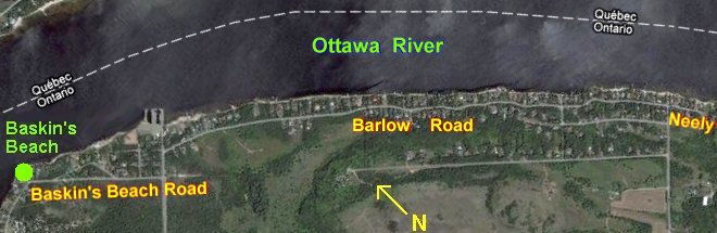 Google Satellite View of Dunrobin Shore - Baskin's Beach
Ottawa River West: Ontario Route Directions: From the northwest end of Baskin's Beach Road return 1.2 km east along it to Vance's Side Road. Turn right or southwest onto Vances and go 1.1 km to Torwood Road. Turn left or northwest onto Torwood and head into the next site, Greenland.
Return to Ottawa River West: Ontario.
Return to Birding Ottawa Table of Contents.
|