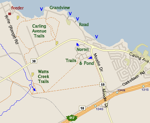
WATTS CREEK TRAILS
Spring: ** Summer: ** Fall: *** Winter: *
Independent Directions to this Site: From Highway 417 (The Queensway) take exit 134 (Moodie Drive). If travelling west, the 0.4 km offramp dumps you right or north onto Moodie. If driving east, a 0.3 km offramp brings you to Moodie Drive, where you will turn left or north onto it and in 0.5 km join the westbound offramp traffic. Both groups will now follow Moodie Drive north 1.3 km from here to Carling Avenue. Turn left or northwest on Carling and go 2.2 km to Rifle (Range) Road. Turn left onto the southern extension of Rifle Road and drive 0.1 km to where the street is gated and park off to the side at the entry point to the Watts Creek Trails.
Ottawa River West: Ontario Route Directions: From the parking lot for the Carling Avenue Trail, turn right or west onto Carling and go 1.2 km to Rifle (Range) Road. Turn left onto the southern extension of Rifle Road and drive 0.1 km to where the street is gated and park off to the side at the entry point to the Watts Creek Trails.
 Map of the Watts Creek Trails area
Site Description and Birding Information: The sewage treatment lagoons here have been closed, but the roadway to where they were are now part of the Greenbelt trail system. The old roadway passes Watts Creek, where the tangles are often good for migrants. Green Heron has been found along the creek here. Upon entering the deciduous woodland the becomes more of a gravel trail, wide and smooth, and immediately branches. The left or eastern route eventually comes out just south of the Nortel complex and the Nortel (Moodie Drive) Marsh & Trails site.
The righthand or straight branch goes south, winding past some productive marshy areas (breeding Wood Ducks and Rusty Blackbird migrants in the autumn) and excellent deciduous woodland with lots of wild food and tangles (great for landbirds in migration, especially sparrows). The area is currently being disrupted by the construction of a major sewer trunk line, necessitating some detours in the trails. This site is directly north of the Stony Swamp Loop Corkstown Road site.
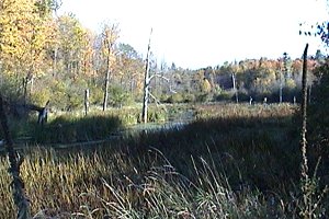 Marsh along the Watts Creek Trail
Ottawa River West: Ontario Route Directions: From the Watts Creek Trails parking area, return 0.1 km north on the southern extension of Rifle Road to Carling Avenue. Cross Carling and enter the next site, Rifle (Range) Road.
Return to Ottawa River West: Ontario.
Return to Birding Ottawa Table of Contents.
|