LA FERME SOLEIL
Spring: *** Summer: ** Fall: ** Winter: *
Independent Directions to this Site: Going north on Autoroute de la Gatineau or Highway 5 take Exit # 2, the Autoroute 50 east exit. Follow the long, 1.0 km, ramp over Brewery Creek and onto Autoroute 50 headed north. Proceed 30 km to exit 166 (the final exit on 50 at this time), following the exit ramp 0.6 km as it loops back around to Rue Notre-Dame. Turn left or south and go 0.6 km SSE to where Chemin de Montréal or Highway 148 join Notre-Dame. Continue straight SSE 0.2 km to where Chemin de la Quai splits off to the right. Continue on Chemin de Montréal or Highway 148 by bearing left or ENE and go 3.4 km to La Ferme Soleil on the left or north side of the road. The area of interest is opposite the farm on the right or south side of the highway. There is room to park well off the roadway along the wide shoulder.
Ottawa River East: Quebec Route Directions: From the pond behind the millworks (off Chemin Wilfred-Lépine), return 0.2 km west to Chemin Wilfred-Lépine. Turn right or north on it and return 0.4 km to Chemin de Montréal Ouest or Highway 148. Turn right or ENE onto it and proceed 1.3 km to La Ferme Soleil on the left or north side of the road. The area of interest is opposite the farm on the right or south side of the highway. There is room to park well off the roadway along the wide shoulder.
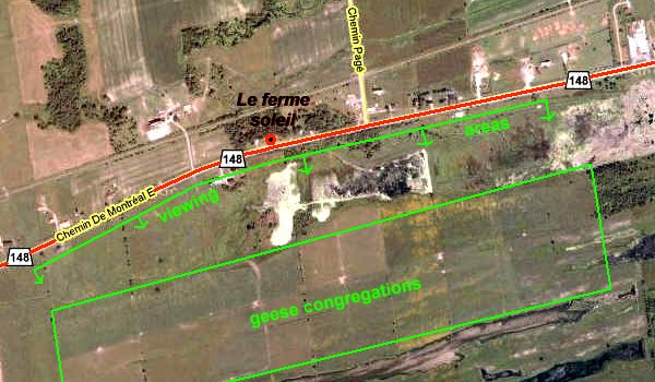 Google Satellite Map of La Ferme Soleil Area
Site Description and Birding Information: The extensive fields opposite La Ferme Soleil are inudated by geese in the spring. A hollow runs parallel to the highway and the far slope allows good viewing of individual birds despite the lack of elevation. Snow Geese are uncommon but regular among the thousands of Canada Geese. Careful scanning has produced several rarities here, including Greater White-fronted Goose (Apr. 17, 1987, May 4, 1988 (2), Apr 29, 1990, Apr. 22, 2001, May 5, 2009), Ross' Goose (with 40 Snow Geese, Apr. 26, 1997) and Barnacle Goose (of questionable origin). Around 0.5 km ENE of the farm, a creek crosses the road and then runs ENE alongside it and eventually (3.5 km) into Baie de Lochabar. The hollow wherein runs the creek contains interesting marshy land.
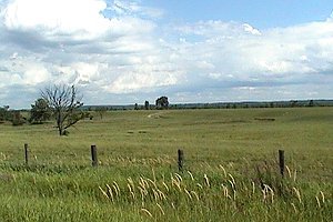 View of the Fields Opposite La Ferme Soleil
Ottawa River East: Quebec Route Directions: From the fields opposite La Ferme Soleil, proceed 3.5 km ENE on Chemin de Montréal Ouest or Highway 148 to pull off on the wide shoulder either side of a trailer home (# 962). The road curves gently up a hill to this point and provides excellent views of the next site on this route, Baie de Lochaber.
Return to Ottawa River East: Quebec.
Return to Birding Ottawa Table of Contents.
|