MOUTH OF GREEN'S CREEK
Spring: *** Summer: ** Fall: *** Winter: **
Independent Directions to this Site: From Highway 417 (The Queensway) take exit 113 (Ottawa-Carleton 174, formerly Highway 17). Stay in the left lanes to take this exit. Go WNW 4.2 km to the Montreal Road/St. Joseph Boulevard exit. Exit to the right and take the 0.3 km offramp to Montreal Road. Turn left or southwest onto it and go 0.5 km to Shefford Road. Turn left or NNW onto it and go 1.6 km to a parking area at the end of the street. Go on foot north across the Eastern Parkway to the Ottawa River. The easy walking trail extends from here 2.4 km to the next site on this route, the Mouth of Green's Creek.
Ottawa River West: Ontario Route Directions: From Upper & Lower Duck Islands return to the boat launch and parking lot at the Airbase Woods. Return the 0.6 km to Blair Road and turn right or SSE on it. Go 1.6 km SSE on Blair to Montreal Road. Turn left or ESE on it and drive 2.3 km to Shefford Road. Turn left or NNW onto Shefford and proceed 1.6 km to the end. There is a small parking area here. Go on foot north across the Eastern Parkway to the Ottawa River. The easy walking trail extends from here 2.4 km to the next site on this route, the Mouth of Green's Creek.
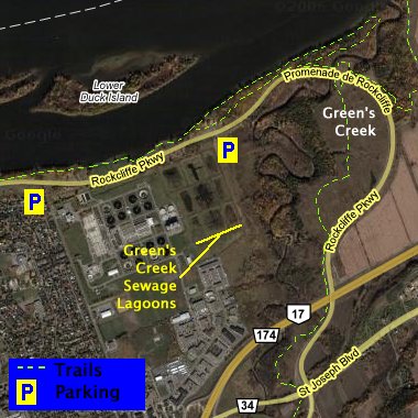 Google Satellite Map of Mouth of Green's Creek
Site Description and Birding Information: This area has lots to offer the birder. Well-maintained paths parallel the Ottawa River all the way to the mouth of Green's Creek and beyond. Near the creek mouth there are many smaller pathways meandering through the forested areas. Look for diving ducks at the outflow. This area has been saved partly because the clay soil constitutes unstable material for building. Part of this area is protected by the Green's Creek Conservation Area, which extends southward from the river to Innes Road in Blackburn Hamlet. This beautiful spot is great for spring migrants.
The Green's Creek sewage lagoons are also in this area, just west of the creek. They have been closed to birders for some years now, and don't appear to be used much. They have the laughable double-speak name of R.O. Pickard Environment Centre now. Though access is denied at the gate, from the hill at the northeast corner of the lagoons (look for the raised dykes), one can see into some of the ponds. Many good records came from these lagoons in the past.
Ottawa River West: Ontario Route Directions: From the Mouth of Green's Creek return to your car at the north end of Shefford Road. Drive 1.6 km SSE on Shefford to Montreal Road. Turn left or ENE on it and drive 0.5 km to the Ottawa-Carleton 174 (old Highway 17) on ramp. Turn right and loop around 0.2 km onto Rte 174 going northeast. Follow 147 for 5.9 km to the Place d'Orléans exit. Take the 0.3 km offramp to the right to Place d'Orléans. Turn left or northeast onto it and go 0.3 km to Champlain Street. Turn left or NNW on it and drive 1.1 km to its end. Park here, looking out onto the Teal Cove Marshes.
Return to Ottawa River East: Ontario.
Return to Birding Ottawa Table of Contents.
|