SHAW ROAD & N. PAKENHAM CONC. 12
Spring: * Summer: ** Fall: * Winter: *
Independent Directions to this Site: From Highway 417 (The Queensway), take the Antrim exit and drive northeast 0.8 km to Antrim and Highway 17. Turn left or northwest on 17 and go 6.2 km to the Galetta Sideroad. Turn left onto it and drive 3.0 km to where it becomes Highway 15 (Lanark 29). Then continue southwest for another 1.1 km to leave Highway 15, but continue straight southwest onto Shaw Road or Lanark 22. Continue 1.3 km further on it to the junction of Shaw Road and North Pakenham Concession 12.
Mississippi River Valley Route Directions: From Ski Hill Road - Mount Pakenham, return to the righthand turn that puts you back on Lynx Hollow Road and then return the 0.6 km to McAffy Road. Turn left or northeast onto it and drive 1.3 km to Highway 15 (Lanark 29). Turn left or north onto 15 and follow it through Pakenham for a total of 3.7 km to N. Pakenham Conc. 12. Turn left to continue northwest (rather than turning northeast as Highway 15 does), and go 3.2 km to the junction of Shaw Road and North Pakenham Concession 12.
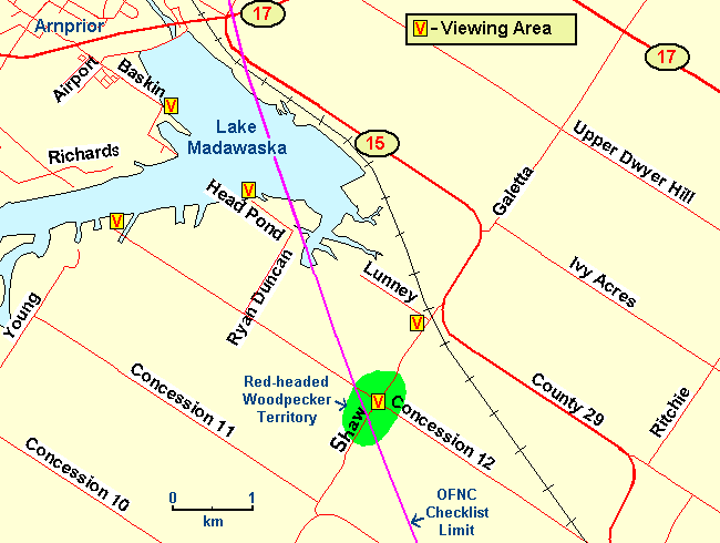 Map of the Shaw Road and North Pakenham Concession 12 area
Site Description and Birding Information: This junction, inside the circle by only a few hundred metres, has hosted nesting Red-headed Woodpeckers in each of the summers from 2002 to 2008 inclusive. Three adults seen July 23, 2006. A small pasture woodlot with dead trees in it and a farmstead with large trees seem to provide the attraction. Often seen flying between telephone poles and the woods or trees. Easily seen from the road. This species is a rare and disappearing breeder in our checklist circle.
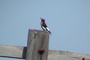 Red-headed Woodpecker at this Site - July 17, 2004
Also of note here is the Osprey nest on the power pylon to the northeast. It can be seen from the corner, but is better viewed from where the power lines cross Shaw Road 1.2 km to the northeast. An even closer look, but at a steeper angle, can be had from Lunney Road (turn left just before reaching the powerline crossing).
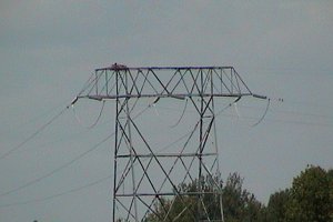 Osprey Nest on the Power Pylon
Mississippi River Valley Route Directions: From Shaw Road & N. Pakenham Conc. 12, go 1.8 km northwest on N. Pakenham Conc. 12 to Ryan Duncan Road. Turn right or northeast onto it and 1.1 km to Head Pond Road. Turn left or northwest on it and proceed 0.7 km to its end at the next site on this route, Lake Madawaska.
Return to Mississippi River Valley.
Return to Birding Ottawa Table of Contents.
|