TRAIL 25-5 ON DWYER HILL ROAD
Spring: ** Summer: ** Fall: ** Winter:**
Independent Directions to this Site: From Highway 416 take exit 49 (Roger Stevens Drive). If southbound, a 0.4 km offramp dumps onto Bankfield, where you will turn right or southwest. If northbound, the 0.4 km offramp brings you to Bankfield, where you will turn left or southwest onto it and in 0.4 km join the southbound offramp traffic. Both groups will now follow Roger Stevens Drive southwest 18.6 km to the Dywer Hill Road. Turn left or southeast on it and proceed 1.4 km to the pulloff for the trailhead (marked by a "25-5" sign) of Trail 25-5 on Dwyer Hill Road.
Marlborough Forest Loop Route Directions: From wherever you are on Flood Road, return southwest to Dwyer Hill Road. Turn right or northwest on it for 2.6 km to the pulloff for the trailhead (marked by a "25-5" sign) of Trail 25-5 on Dwyer Hill Road.
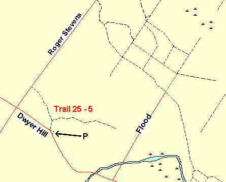 Map of the Trail 25-5 on Dwyer Hill Road Area
Site Description and Birding Information: This trail branches after a few hundred metres. The north trail comes out on Roger Stevens Drive in about 1.5 km, while the eastern branch heads off toward Flood Road in around 3 km.
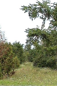 Trail 25-5 on Dwyer Hill Road
Marlborough Forest Loop Route Directions: From the pulloff for the trailhead of Trail 25-5 on Dwyer Hill Road, turn right or northwest onto Dwyer Hill Road. Proceed 1.4 km to Roger Stevens Drive and turn right or northeast onto it. Drive 1.7 km to the pulloff to the right or southeast for the trailhead (marked by a "21-6" sign) of the next site in the loop, Trail 21-6 on Roger Stevens Drive.
Return to Marlborough Forest Loop
Return to Birding Ottawa Table of Contents
|