COBBS LAKE CREEK at LALONDE ROAD
Spring: *** Summer: * Fall: ** Winter: *
Independent Directions to this Site: From Highway 417 (The Queensway) take exit 96 (Boundary Road). Proceed 2.0 km NNW on Boundary Road to Russell Road (Regional 26). Turn right or ESE onto Russell Road (Regional 26, then Prescott - Russell 2) and drive 31.9 km to Boudreau Road (c. 1.5 km after the sharp lefthand turn on Russell Road at Cobbs Lake Creek). Turn left (actually straight) or NNW onto Boudreau and proceed 1.5 km to Lalonde Road. Turn left or WSW onto Lalonde and go 1.2 km to Rollin Road. Cross it and park at the barricade on Lalonde Road overlooking the Cobbs Lake Creek floodplain.
Spring Flooding Route Route Directions: From Cobbs Lake Creek at Du Lac Road, return NNW to Maisonneuve Road and turn right or ENE onto it. Drive 1.3 km to Rollin Road and turn right or SSE onto it. Proceed SSE along Rollin 1.8 km to Lalonde Road. Turn right or WSW onto Lalonde and park at the barricade on Lalonde Road overlooking the Cobbs Lake Creek floodplain.
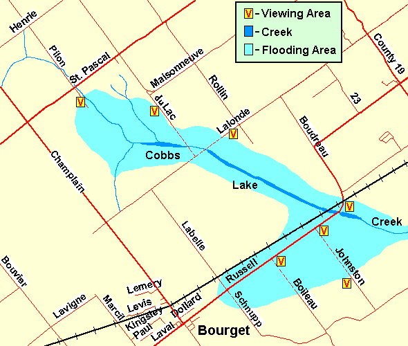 Map of Cobbs Lake Creek at Lalonde Road area
Site Description and Birding Information: This is the third in a series of spots from which to view the Cobbs Lake Creek floodplain. During the flood season, the road is closed by a huge cement barricade, allowing only the brave or stupid to pass. You may have to walk WSW along it to get a closer view of the birds. If it is open, the flooding will no longer be as extensive and the birds likely gone.
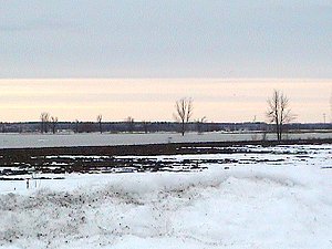 Floodplain Area off Lalonde
Spring Flooding Route Route Directions: From Cobbs Lake Creek at Lalonde Road, return ENE to Rollin Road and then continue ENE on Lalonde 1.2 km to Boudreau Road and turn right or SSE onto it. Proceed 1.5 km to Prescott - Russell 2 and turn right (actually to go straight) onto it. Continue SSE 1.5 km on P-R 2 to the sharp righthand curve where P-R 2 is also called Russell Road. The few kilometres from the corner to the beginning of the hill going up into the town of Bourget makes up the next site on this loop, Cobbs Lake Creek at Russell Road (Bourget).
Return to Spring Flooding Route.
Return to Birding Ottawa Table of Contents.
|