ALGONQUIN PROVINCIAL PARK
Spring: *** Summer: *** Fall: *** Winter: ****
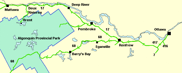
Independent Directions to this Site: To reach Algonquin Provincial Park from Ottawa, take Highway 417 west. Then, as it loses its 4 (lanes, that is), and becomes the two-lane Highway 17, follow that. Proceed 80 km from Ottawa to the turnoff for Renfrew at Highway 60. From here, you can go west to visit the southern portion of the park that lies along Highway 60; or go northwest on Highway 17 to explore the northern and eastern sides of the park. The southern portion lies about 3 hours west of Ottawa by car, while the northern section is about 4 hours and the eastern section about 2 hours. These times vary considerably depending on the season. In summer, heavy usage of narrow, winding roads can cause considerable delay. Likewise, weather conditions in winter can wreak havoc with schedules.
 Ottawa to Algonquin Map
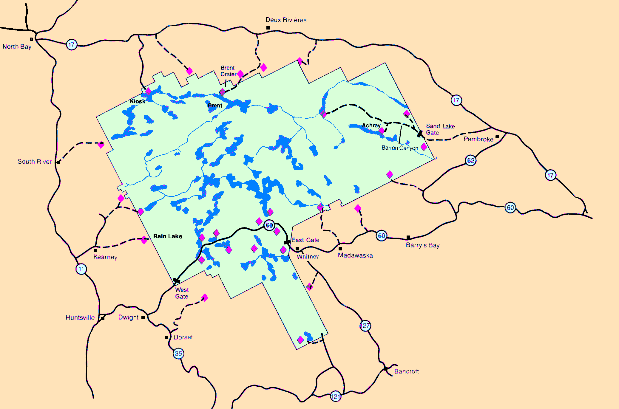
To reach the southern section, the "Parkway Corridor", take Highway 60 from its turnoff at Highway 17 near Renfrew. Drive west on 60 for around 125 km to reach the east gate of Algonquin Park. The next 56 km of Highway 60 passes through the park. It is numbered from the west end, so, as you enter here, you are at Kilometre 56. The Parkway Corridor map and other information provided by the park often refers to roads, trails and other features by their Kilometre post within the park. The park's Visitors' Centre, for instance, is at Kilometre 43.
To reach the eastern access (the Sand Lake Gate), continue along Highway 17 to the northwest of Renfrew for about 52 km (about 6 km beyond Pembroke) to the turnoff on the left at the sign for Lake Traverse, Achray campground, Barron Canyon and Sand Lake Gate of Algonquin Park. Turn left and proceed around 30 km on Sand Lake Road to Sand Lake Gate and the park. Access to Lake Traverse is near km 72.
To reach the northern access, continue along Highway 17 to the northwest of Renfrew for about 164 km (about 3 km beyond Deux Rivieres) to the turnoff on the left at the sign for Brent and Cedar Lake, Algonquin Park. Turn left and proceed around 25 km to the park and 35 to Brent on Cedar Lake.
 Map of Algonquin Provincial Park
Site Description and Birding Information: Algonquin Provincial Park, created in 1893, is the oldest provincial park in Ontario. It consists of 7,725 square kilometres of lakes, rivers and forest situated on the southern part of the Canadian Shield, between Georgian Bay and the Ottawa River. This massive 110 by 70 km (roughly) block is not, however, a wilderness area. Since Europeans first came here it has been logged and 75% of the park is still subject to controlled timber cutting. That being said, it still has large amounts of prime habitat and easy access by road, trail and canoe. The park is extremely popular in summer and if you plan to stay there in that season, you will need reservations. The park's Information Line is (705) 633-5572 (0800 to 1630 hrs, 7 days a week). E-mail for information: info@algonquinpark.on.ca.
The park straddles the transition zone between the southern hardwood and the boreal evergreen forests. This is the prime factor leading to the park checklist having 260 species, over half which breed here. Southern deciduous wood species are found here alongside the boreal forest birds. Algonquin is probably the easiest place in southern Ontario to find many northern species such as Spruce Grouse, Gray Jay, Boreal Chickadee, Yellow-bellied and Olive-sided Flycatchers, Golden Eagle, Black-backed and less common Three-toed Woodpecker, both Red & White-winged Crossbill and other northern finches. Abundance of winter finches is dependent on the quality (i.e. quantity) of the cone crops. As this varies considerably from year to year, it is wise to determine the current situation. Ron Pittaway's Winter Finch Forecast is passed along on the ONTBIRDS listserv in fall or early winter. For more information regarding ONTBIRDS, a free service to birders, check out the Listserv section of the Birding Ottawa Useful Tools and RBAs page. If you didn't keep it or haven't yet seen it, you can find it here on NeilyWorld, thanks to Ron, on our Winter Finch Forecast page. You also need to be aware of road conditions and closures in winter (call the park info line).
Birders seeking Algonquin's "boreal" species (Spruce Grouse, Black- backed Woodpecker, Gray Jay, Boreal Chickadee) in the Highway 60 Corridor should concentrate on the three traditional areas which usually produce the best results: 1) the Old Railway from Arowhon Road (km 15.4) to West Rose Lake, 2) the Spruce Bog Boardwalk (km 42.5), and 3) the Opeongo Road (km 46.3). The first area, the old rail bed from halfway along the Arowhon Road to the Mizzy Lake Trail is good in all seasons. Number two, the Spruce Bog Boardwalk is a 1.5 km loop trail where Spruce Grouse are often seen. The third area, the Opeongo Road (c. 5 km long) is gated at the Cameron Lake Road (c. 2 km in) in winter, but you may walk along the road beyond the gate. Cameron Lake Road is also good, but may not always be plowed.
Feeders at the East Gate and the Visitor Centre are worth checking for Pine Grosbeaks and Common Redpolls. One or two Hoary Redpolls are sometimes seen in the Common Redpoll flocks. Gray Jays may also be seen around these feeders. Check the Lake of Two Rivers campground in winter for Black-backed Woodpeckers, 5 were found there on the CBC in Dec. 29, 2005. Great Gray Owls are seen rarely, usually in winter (Jan. 17, 2004 - km 20; Nov. 1, 2004 - km 56.5 on the Barron Canyon Road; Nov. 6, 2004 - near Hogan Lake).
Nelson's (Sharp-tailed) Sparrow can be found each autumn (late September to early October) in the sedge marsh adjacent to Lake of Two Rivers Campground (chest waders needed). Leconte's Sparrow is found almost yearly in suitable long grass and sedge habitat from late September to early October. One spot to check at that time is the long grass at the Lake of Two Rivers end of the Old Airfield. The Old Airfield is located at Km 30.6 on Highway 60 (Km 0 at the West Gate). Another spot to look for both Le Conte's and Nelson's (Sharp-tailed) Sparrows is the wetland at the south-central end of Lake Travers (canoe access). A canoe is advisable but it is possible to walk the shoreline and see everything. The Nelson's Sparrows are in a wetland midway along the south shore (45.959074 N, 78.049864 W). In years with the very low water levels they are concentrated near where the creek enters the lake.
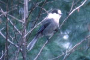 Gray Jay
Rarities seen in this locale include: Northern Hawk Owl and Great Gray Owl (nearly every winter), Spotted Towhee (Oct. 30, 2005), Cave Swallow (Nov. 7, 2005), Greater White-fronted Goose (c. May 6 to at least May 20, 2006).
For further information on this site see the Algonquin Provincial Park website. There are many events, including bird walks, conducted by the Park Naturalists. Several excellent publications are available through the park, including a Checklist and Seasonal Status of the Birds of Algonquin Provincial Park and the beautiful Birds of Algonquin Provincial Park by Dan Strickland, a booklet describing the more common species and their habitats.
Return to Favourite Outlying Sites.
Return to Birding Ottawa Table of Contents.
|